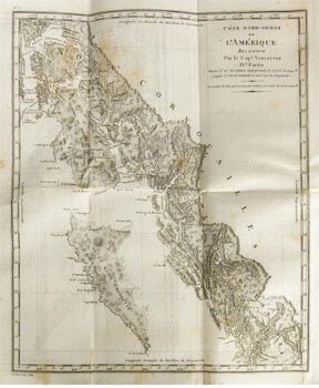
Vancouver, George; P.F. Henry, translator — Voyage de Découvertes, à L'Océan Pacifique Du Nord, Et Autour Du Monde, Composé de 17 Vues Et 9 Cartes. (Translation of of a Voyage of Discovery to the North Pacific Ocean, and Round the World ). First Edition in French
Paris, Didot Jeune, An X (1802). 8vo. Full contemporary mottled calf. 17 engraved views and 8 large folding maps. Includes views of towns in California, Washington State, Chile and Canada. This is the atlas plate volume only, vol. 6, which is often missing. Light foxing. Bookplate of Jn. Bte. Barnel. OCLC Number:162445325; Wright Howes, the Final Edition, no. 23; ayes 85-93; Hill 303-4; Lada-Mocarski 55; Sabin 98441; Tweney 89, 78 (ref); Cowan 655; Wagner Northwest Coast I 239-50; In-8 : 2f. 17 vues et 9 cartes (dont 8 dépliantes). Rousseurs et taches, petites déchirures aux pliures des cartes, ex-libris sur contre plat. Plein veau fauve de l'époque, dos lisse, guirlande dorée sur les plats. Voyage effectué entre 1790 et 1795. La ville de Vancouver au Canada doit son nom à ce grand explorateur. Up to 1791, when Vancouver left on his voyage, the west coast had only been fitfully mapped. The coasts of Alta California were mapped to a considerable extent by the Armada Real and the French expedition of Jean-François de Galoup, Comte de La Pérouse in 1786. Further north, the picture was far less clear. Captain James Cook had mapped parts of what is now western Washington State, the west coast of Vancouver Island and Alaska's Price William Sound and Cook Inlet (the site of modern Anchorage). However, much of the inlets and islands (notably the Salish Sea) were entirely unknown. In 1790, the American adventurer Robert Gray discovered and mapped the lower reaches of the Columbia River. As part of a larger mission towards completing the work of Cook and La Pérouse throughout the Pacific, Vancouver was dispatched by the Admiralty on his epic voyage. Captain George Vancouver (1757-98) was one of the most important explorers of the 18th Century. He notably served on Cook's Third Voyage, and so gained valuable experience exploring and mapping the Pacific Northwest. In 1791, he was chosen to captain the HMS Discovery, with a mission to discover and chart the vast areas of the Pacific that were still unknown. The expedition included the esteemed botanist Archibald Menzies. The HMS Discovery and its companion ship, HMS Chatham, left England in 1791 and travelled to Cape Town, Australia, New Zealand, Tahiti, and China, all the while collecting botanical samples and surveying coastlines. Sailing across the Pacific to North America, Vancouver followed the coasts of Oregon and Washington northward. Vancouver entered the Strait of Juan de Fuca, between Vancouver Island and the Washington's Olympic Peninsula in April 1792. Vancouver proceeded to survey every inlet and outlet on the west coast of the mainland, all the way north to Alaska. Most of this work was done employing modern techniques of triangulated surveys. As noted on the present map, many of the charts were drafted by Vancouver's chief hydrographer, Lieutenant Edward Roberts. Many important features in the Pacific Northwest were named by Vancouver, including the volcanoes Mounts Ranier, Baker, Hood and St. Helen's, and the bodies of water Puget Sound, Burrard Inlet and Howe Sound. Vancouver's expedition became the first Europeans to encounter the sites of the future cities of Seattle and Vancouver, B.C. In June 1792, off of Point Grey (Vancouver, B.C.), the Vancouver's expedition met with the Spanish expedition led by Dionisio Alcalá Galiano and Cayetano Valdés y Flores. In spite of the tensions that exited between Britain and Spain, the enlightened Vancouver, who placed scientific discovery above nationalism, befriended the Spaniards. The two parties exchanged maps and information, whereupon Vancouver was "mortified" to learn that the Spanish already possessed a crude chart of the Strait of Georgia based on the exploratory voyage of José María Narváez in 1791. For three weeks the parties cooperatively explored the Georgia Strait and the Discovery Islands. Vancouver then sailed to Nootka Sound (on the west coast of Vancouver Island), which was already a major fur-trading center, disputed between Britain and Spain. There Vancouver met the great Spanish explorer, Juan Francisco Bodega y Quadra. While diplomacy over the control of Nootka was inconclusive, Vancouver and Quadra shared charts and information and proved the insularity of Vancouver Island. Vancouver also acquired a copy of Robert Gray's pioneering chart of the lower Columbia River. Vancouver then sailed south down towards Oregon. He dispatched Lieutenant William Robert Broughton to explore the Columbia River. Broughton progressed as far as the Columbia River Gorge, producing a fine map, aspects of which are embraced by the present chart. Vancouver continued south along the coast of Spanish Alta California, visiting Chumash villages at Point Conception and San Buenventura. Vancouver then wintered in the Sandwich Islands (Hawaii), and worked towards creating what would become the first complete chart of the islands. In the spring of 1793, Vancouver returned to British Columbia and sailed northwards, all the while conducting surveys of the treacherous Inland Passage. He arrived at Alaska's Alexander archipelago, charting and circumnavigating Prince of Wales Island, Revillagigedo Island and mapping parts of the coasts of Mitkof, Zarembo, Etolin, Wrangell, Kuiu and Kupreanof Islands. He then sailed south to California, before, once again, wintering in Hawaii. In 1794, Vancouver sailed far north to Cook Inlet, the northernmost point of his exploration, and from there followed the coast southwards. He then charted the east coasts of Chichagof and Baranof Islands, circumnavigated Admiralty Island, explored to the head of Lynn Canal, and charted the rest of Kuiu Island and nearly all of Kupreanof Island. Vancouver then set sail for Great Britain by way of Cape Horn, returning to England in September 1795, thus completing a global circumnavigation. Vancouver's account of the voyage, along with an atlas of his charts was first published in London in 1797. Interest in Vancouver's discoveries was intense across Europe and America, and various editions of his charts were issued. The present chart is a rare early French edition, masterfully engraved in Paris by Alexandre Blondeau. The quality of the engraving and the paper used for this edition is noticeably superior than that employed for the 1797 London edition. .