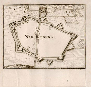
Zeiler, Martin (1589-1661); Johan Peeters, artist; Caspar Merian, publisher (1627-1685) — Plan of Narbonne from Topographia Galliae. First Edition of the Engraving
Franckfurt am Mayn: Caspar Merians, 1655-1656. 16.2 x 16.2 cm. page size. Mounted on a support sheet... Planche figurant une vue de Narbonne et un plan des fortifications de la ville, publiée dans la "Topographia Galliae"de Merian. De 1655 à 1661, Gaspard Merian édite en allemand et en caractères gothiques, les 13 parties de la Topographia Galliae (Topographie de la France), ouvrage qui illustre la France du XVIIe siècle. Le texte est du géographe allemand Martin Zeiller. Gaspard Merian s'est également inspiré de gravures déjà publiées de Nicolas Tassin.. "Gaspard (ou Kaspar) Merian était à la fois le fils et l'élève du graveur Matthias Merian. À la mort de son père en 1650, il prit sa suite à la tête de sa maison d'édition à Francfort sur le Main. Ce faisant Gaspard Merian héritait également de la Topographia Germaniae, atlas topographique des provinces de langue allemande, gravé par son père pour les planches et dont les textes étaient dus à Martin Zeiller. Les premiers volumes étaient parus en 1642. Gaspard allait poursuivre cette publication et l'enrichir progressivement de la topographie de la France, de l'Italie, des Pays-Bas, de la Suisse. OCLC Numbers 1292069102 and 93034251.. UK Royal Collection description: This volume, part of a set on the topography of France, was first published in 1655. It covers Paris and the Ile de France, and includes numerous detailed engravings and maps of the various cities, towns, and notable buildings in the region, accompanied by text written by the German scholar Martin Zeiler (1589-1661)... Zeiler was born in central Austria in 1589 but his family, being Protestant, was forced to leave the country and as a result Zeiler was educated in the city of Ulm. He later moved to Wittenberg to study law and history but returned to Ulm in 1629 and began to publish multiple works on history and topography. Around 1640, Zeiler was approached by the publisher and engraver Matthäus Merian (1593-1650) to write the text for his multi volume work which aimed to collate his many detailed engravings of German, French and Italian towns. The enterprise ran to over 60 volumes, a huge endeavour for the seventeenth century, and employed notable engravers such as Wenceslaus Hollar. Merian died in 1650 but his sons managed to complete the publication with the final volume published soon after Zeiler's death in 1661.. The engravings in these volumes are very detailed and often depict birds-eye or panoramic views of cities and notable estates throughout France and the Holy Roman Empire. This volume is of particular interest because it contains very detailed depictions of the development of Paris between 1620 and 1655, most notably the progress of Louis XIII's extension of the Louvre which was completed in 1638. There have also been later additions to the engravings contained in the volume, a previous owner has inserted cropped plans and elevations of Les Invalides, a project that was not started until 1670. .