
Antiquariaat Goltzius
Libri
1109 libri di Antiquariaat Goltzius

Climats Géologie, Faune et Géographie Botanique du Brésil
LIAIS, EMMANUEL, · 1872
€230.00 ($252.48 | £191.56 | ¥40,219)
Paris, GARNIER Freres, 1872, 640 pages and folding map, half linnen binding, provenance from the library of Geologisch Instituut Amsterdam, library stamps on spine and on several pages. Good copy. Scarce.
De Bussy's atlas van Nederland voor kantoor, school en thuis
1923
€57.50 ($63.12 | £47.89 | ¥10,055)
{1923], large folio atlas of the Netherlands. Haarlem edition: all plates have advertisments from the region of Haarlem, original binding, not in a good state, bloc is loose, textpages missing. Plates of the Netherlands and provinces are coloured
Plattegrond van Valkenburg,
1880
€34.50 ($37.87 | £28.73 | ¥6,033)
[no date, no publisher], 1880-1900, small printed map of the city of Valkenburg on linnen. 22x21cm, some minor damage to the map. Attractive
Kaart van Drenthe, ontworpen en getekend door J. Kuyper
KUYPER, J., · 1888
€143.75 ($157.80 | £119.72 | ¥25,137)
Leeuwarden, Hugo Suringar, 1888, 7th edition, map of Drenthe in original folder, with accents in colour, 43x53cm. attractive map of drenthe. 125
W. Drugulin's Historischer Bilderatlas. Verzeichnis einer Sammlung von Einzelblättern zur Cultur- und Staatengeschichte von fünfzehnten bis in das neunzehnte Jahrhundert. Zweiter Theil: Chronik in Flugblättern.
DRUGULIN, W., · 1867
€57.50 ($63.12 | £47.89 | ¥10,055)
Leipzig, Leipziger Kunst-Comptoir, 1867, 500 pages, original paper on boards binding with some damage mostly on the spine. By insertions in the book, the text has been updated.
Tabula qua Graecia Superior, qualis tempore belli Peloponnesiaci ineuntis fuit descripta est C. Odofredo Muller with Zur Karte des Nördlichen Griecnlands von K. D. Müller, beilage zu dem Werke desselben Verfassers die Dorier
MULLER, K. OTTFRIED, · 1831
€143.75 ($157.80 | £119.72 | ¥25,137)
Map: J&C Walker sculpsit, paper on linnen, in original paper folder. Book: Breslau, Josef Max und Komp., 1831. 37 pages, original marbled paper binding, This early 19th century detailed and hand coloured map of the north of Greece and the accompagnying bookare rarely found to...
Photograph, foto, Garderen, church, kerk, pastorie, Dorpsweg, Stroe
0
€23.00 ($25.25 | £19.16 | ¥4,022)
Two undated photographs of the village of Garderen (province Gelderland). One depicts the Hervormde Kerk with the pastorie at the Dorpsweg on the right. The other depicts the road through the woods between Garderen en Stroe. Late 19th, early 20th century.
Haarlem (prov. Noord-Holland). Origineel gelithografeerd kaartje uit de Gemeenteatlas ca. 1868, 17x22 cm.
Kuyper, J. · 0
€86.25 ($94.68 | £71.83 | ¥15,082)

Dilapidated church-tower surrounded by houses [Set title: Amenissimae aliquot regiunculae... (4th volume)]/Kerktoren met huizen.
Velde, Jan van de II (c.1593-1641) · 0
€287.50 ($315.60 | £239.45 | ¥50,274)
Dilapidated church-tower surrounded by houses; two monks walking towards the tower and two others sitting beside a ruin. A city in the left background. Numbered \"26\" beside the sitting monks. l Etching on paper, trimmed to plate mark, total: 124 x 190 mm, state I/4; weak co...

Farm along a country road [Set title: Amenissimae aliquot regiunculae... (4th volume)].
Velde, Jan van de II (c.1593-1641) · 0
€287.50 ($315.60 | £239.45 | ¥50,274)
Farm along a country road; small stone bridge in the front, three men on the path on the right. Numbered on the bottom and top right, '2' and '4' respectively. The number '95' has been added at the bottom, center. l Etching on paper, with some margin; plate mark: 123 x 190, t...

Farmyard with inhabited ruins [Set title: Amenissimae aliquot regiunculae...] Boerderij met bewoonde ruines.
Velde, Jan van de II (c.1593-1641) · 0
€402.50 ($441.84 | £335.23 | ¥70,384)
A print representing a landscape with inhabited ruins of a house on the right. A woman walking with a child by the hand, seen from behind, walking both towards the house. Not yet numbered. First half seventeenth century. l Etching on paper, with some margins; plate mark: 122 ...

Farm built against a square tower [Set title: Amenissimae aliquot regiunculae...]/Boerderij met vierkante toren.
Velde, Jan van de II (c.1593-1641) · 0
€287.50 ($315.60 | £239.45 | ¥50,274)
A print showing a farm built against a square tower; figures in the foreground left. Numbered at the bottom and at the top, '11' and '2' respectively. l Etching on paper, with some margins; plate mark: 135 x 198 mm, total: 147 x 210 mm, state II/3; 'Pro Patria watermark'; Hol...

Amenissimae aliquot regiunculae... [Set frontispiece]/Frontispice van boek met 26 landschapsetsen.
Velde, Jan van de II (c.1593-1641) · 1616
€345.00 ($378.72 | £287.34 | ¥60,329)
Frontispiece to a set of 26 etchings with various landscapes. Plates were reworked over time. An old city gate at the center with two figures walking towards the opening; 'the city walls have crumbled to the point that the portal seems superfluous, merely signifying a liminal ...

Water-mill near a village [Set title: Landscapes and ruins]/Watermolen bij een dorp.
Velde, Jan van de II (c.1593-1641) · 0
€805.00 ($883.68 | £670.45 | ¥140,767)
Water-mill near a village, two monks in the foreground, a pond on the left. Numbered '4' on bottom right. Beautiful etching. l Etching on paper, trimmed within plate; total: 116 x 311 mm; state II/2, evenly yellowed paper, beautiful impression. Some light dirt in the sky; Hol...

Scheeps-tocht, in den jaare 1596, naar Nova Zembla ondernomen.
Picart, Bernard (1673-1733) · 1596
€207.00 ($227.23 | £172.40 | ¥36,197)
Beautiful engraving representing the trip to Nova Zembla (Novaya Zemlya) in 1596 and the unfortunate encounter with the sea lions. Titled at bottom: 'Scheeps-tocht, in den jaare 1596, naar Nova Zembla ondernomen.'. From Le Clerq's <em>Geschiedenissen der Vereenigde Nederlanden...
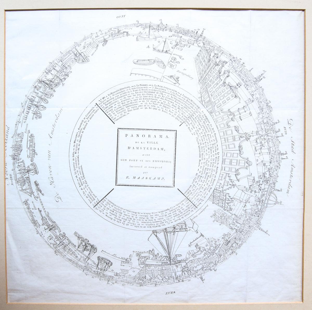
PANORAMA DE LA VILLE D'AMSTERDAM.
Maaskamp, Evert (1769-1834) · 0
€345.00 ($378.72 | £287.34 | ¥60,329)
Anamorphic (?) view on Amsterdam. Landmarks numbered and identified in the middle. Other indications concerning the surroundings also reported in the print. Titled and signed in the center: 'PANORAMA / DE LA VILLE / D'AMSTERDAM, / AVEC / SON PORT en ENVIRONS / inventé et compo...

Portrait of Anna Maria van Schurman (Anna Maria Schuurman).
Desrochers, Etienne (1668-1741) · 1678
€57.50 ($63.12 | £47.89 | ¥10,055)
Bust portrait of Anna Maria van Schurman, artist and poet. While turning to the left, she looks at the viewer, in an oval. Inscribed on the bottom: 'Anne Marie de Scurman / tres Illustre fille, née á Cologne, et Morte /a Vüwert en Frise l'an 1678. ágée / de 71 ans.'; signed at...

Partie Septentrionale du Comte de Hollande...
Sanson, Guillaume (1633-1703) · 1699
€402.50 ($441.84 | £335.23 | ¥70,384)
Map of North Holland, with Tessel island. Large cartouche on the left with title, dedication and explanation concerning the scales adopted for this map. The title is printed from a different plate. Titled: 'PARTIE SEPTENTIONALE DU COMTÉ DE / HOLLANDE. / Dressée sur les Memoire...

Haegse Delftse en Rooterdamse Nacht-Schuÿten [set title: Various ships and views of Amsterdam].
Nooms, Reinier (1623/1624-1664) - Zeeman · 1843
€632.50 ($694.32 | £526.78 | ¥110,603)
From a set of views of Amsterdam and boats; this plate shows the night ferry leaving from Rokin to The Hague, Rotterdam and Delft, carrying passengers. Nr. 5 from volume III; titled at the bottom: 'Haegse Delftse en Rooterdamse Nacht-Schuÿten'; number has been scratched out fr...

ST ANTONIS POORT 1636 [set title: Town Gates of Amsterdam].
Danckerts, Cornelis (1604-1656) after Nooms, Reinier (1623/1624-1664) - Zeeman · 1656
€632.50 ($694.32 | £526.78 | ¥110,603)
Published before 1656, from a set of eight plates representing the town gates of Amsterdam. In this plate the gate of St. Anthony. Titled, dated and signed on the bottom: 'Zeeman delineavit et fecit / St. ANTONIS POORT.1636 / C. Danckerts exc:'. l Etching and dry needle on pa...