
Carte geografiche e topografia
Risultati della ricerca
84168 libri in Carte geografiche e topografia

Vereinigte Staaten von Nordamer
HECK, JOHANN GEORG, · 1855 · Antiquariaat Goltzius
€155.25 ($171.12 | £129.50 | ¥27,329)
Map of the Western half of the United States including Mexico (Texas, Nebraska, Kansas mostly visible). With inset maps of San Francisco, German colony Wartburg, the area around Boston, the rail route between Panama and Chagres, Panama, and New York Bay. Outline coloured engra...

Plan van een gedeelte der rivier de Whaal, de Maas en Merwede, Omtrent het fort Loevestein, Woudrichem, Dalem en Gorinchem. gedaan (...) Juny 1777 (...) op Aanzegging van den Inspecteur Generaal C. Brunings door Hendrik van Straalen.
1779 · Antiquariaat Goltzius
€287.50 ($316.88 | £239.82 | ¥50,608)
Very large (60x100cm including margins, plate 38 x 93 cm) engraved map by Jacob Turpin, Den Haag, of the rivers Waal, Maas, Merwede and Loevestein castle (Slot Loevestein). 1779. l De scheepvaart in de Merwede had in de 18de eeuw regelmatig last van zandbanken en ondieptes. Z...

Literatuurlijst bij : C. Koeman, Geschiedenis van de Kartografie van Nederland.
0 · Antiquariaat Goltzius
€28.75 ($31.69 | £23.98 | ¥5,061)
Modern paper folder with appr. 20 typewritten pages with the bibliography of this important work on cartography. From the library of Geografisch Instituut Utrecht.

OLVEH's Zakkompas voor toerisme in Nederland
1879 · Antiquariaat Goltzius
€57.50 ($63.38 | £47.96 | ¥10,122)
's-Gravenhage : De OLVEH van 1879, [1935], 12 colour (fold out) plates, with fold out map of The Netherlands and all traffic signs of the thirties, Atlantes Neerlandici / compiled and edited by C. Koeman. Volume VI, Olve A1, scarce.
Atlas A.N.W.B. Bl. 23 Brielle
1919 · Antiquariaat Goltzius
€28.75 ($31.69 | £23.98 | ¥5,061)
One colour printed atlaspage on linen, 22x19cm, review 1919.
Atlas A.N.W.B. Bl. 33 Helmond
1928 · Antiquariaat Goltzius
€28.75 ($31.69 | £23.98 | ¥5,061)
One colour printed atlaspage on linen, 22x19cm, review 1928.

Rijwielkaart van de Veluwe met Nunspeet als uitgangspunt.
1900 · Antiquariaat Goltzius
€40.25 ($44.36 | £33.57 | ¥7,085)
Uitgave \"De Veluwe\" Nunspeet. Attractive and detailed chromolithograph map, paper on linen, with information concerning the use of the terrain. Centraal spoorweg and the Zuiderzee. Design by The Graphic Arts Utrecht? Between 1900-1940. 23x21cm. Good state.

Justus Perthes Taschen Atlas der ganzen welt.
1924 · Antiquariaat Goltzius
€51.75 ($57.04 | £43.17 | ¥9,110)
Gotha, Justus Perthes 1924, 96pp and 24 coloured engraved detailed maps of the world, original hardcover tolled linen binding. very good and clean crisp copy. Shows the world after the first world war. Scarce.

Congrès International de Géographie Amsterdam 1938 Excursion a Zeeland 11-16 Juillet.
1938 · Antiquariaat Goltzius
€51.75 ($57.04 | £43.17 | ¥9,110)
Amsterdam, Koloniaal Instituut, [1938], 151pp. original softcover binding, many illustations, maps and charts, includes loose fold out map: The ancient tidal channels of Walcheren.
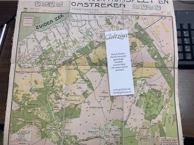
Wandelkaart voor Nunspeet en omstreken.
1900 · Antiquariaat Goltzius
€46.00 ($50.70 | £38.37 | ¥8,097)
Uitgave \"De Veluwe\" Nunspeet. Attractive and detailed chromolithograph map, paper on linen, with information concerning the use of the terrain. Centraal spoorweg and the Zuiderzee. Jugendstil ornaments on top. Between 1900-1940. 37x39cm. Good state.
Topographical map of The Netherlands, topografische kaart van Nederland. Military map of the Netherlands. Bonnebladen.
1927 · Antiquariaat Goltzius
€40.25 ($44.36 | £33.57 | ¥7,085)
One page printed chromo topographical map paper on linen, 50x80cm. a so called bonneblad, based on the projection of Bonne. Attractive topographical maps in colour. scale 1:50000. Present are: Eindhoven (1927-1930), Breda (1936-1938), \"s Hertogenbosch (1927), Bergen op Zoom N...
A.N.W.B. Atlas. Topographical map of The Netherlands, topografische kaart van Nederland. Bonnebladen.
1900 · Antiquariaat Goltzius
€28.75 ($31.69 | £23.98 | ¥5,061)
One page printed chromo lithograph topographical map, paper on linen, 23,4x20cm part of the ANWB Atlas of the Netherlands, a so called bonneblad, based on the projection of Bonne. Attractive topographical maps in colour, scale 1:200000. Dating from 1900-1940. Present are the f...

Beschryving der stadt Delft behelzende een zeer naaukeurige en uitvoerige verhandeling van deszelfs eerste oorsprong, benaming, bevolking, aanwas, gelegenheid, prachtige en kunstige gedenkstukken en zeltzaamheden.
Boitet, R., e.a. · 1729 · Antiquariaat Goltzius
€862.50 ($950.65 | £719.45 | ¥151,825)
Delft, R. Boitet, 1729. Folio, copy on large paper, full leather binding, some rubbing to edges of binding, damage to top of spine, gilt lettering and ornaments on spine, rubbed, gilt faded, hinges suffering on the exterior, binding internally solid. Good but incomplete copy. ...
Mapping the world.
SWIFT, M., · 2006 · Antiquariaat Goltzius
€28.75 ($31.69 | £23.98 | ¥5,061)
Edison, NJ, Chartwell Books, Inc, 2006. Hardcover. 256pp. A very large, oblong hardcover book in fine condition with a near-fine dustjacket. The book is clean and tight, as new; the jacket is fully intact but has some wear and tear on the corners. Reproductions of maps from th...
Topographical map of The Netherlands, topografische kaart van Nederland. Military map of the Netherlands. Bonnebladen. Gorinchem no. 38. (1936)
0 · Antiquariaat Goltzius
€40.25 ($44.36 | £33.57 | ¥7,085)
One page printed chromo topographical map paper on linen, 50x80cm. a so called bonneblad, based on the projection of Bonne. Attractive topographical maps in colour. scale 1:50000.

De waterkeeringen, waterschappen en polders van Zuid-Holland
TEXEIRA DE MATTOS, L.F., · 1906 · Antiquariaat Goltzius
€1,437.50 ($1,584.42 | £1,199.08 | ¥253,042)
The Hague, Martinus Nijhoff, 1906-1961, 10 volumes in 14 (of 15) bindings plus 3 sets of plates in seperate albums, near complete set, part two of volume IV is missing, as well as plate 5 accompanying volume VII part 1. The set is not uniformly bound. Some are bound in red (fa...

Het huis te Boekhorst onder Noordwijkerhout, van voren 1739/Het huis Boekhorst van agteren.
Rademaker, Abraham (1676/7-1735) · 1739 · Antiquariaat Goltzius
€109.25 ($120.42 | £91.13 | ¥19,231)
Two copperplate etchings of Huis Boekhorst, in Noordwijkerhout in the Dutch province of Zuid-Holland, as it appeared in 1739. Drawn and etched by A. Rademaker. Overall size: 220 x 140 mm; plate size: 79 x 112/83 x 114 mm. Good state. Some age related discolouration. Handlaid p...
Help U Zelf / Jaar- en Adresboek van Bloemendaal, Overveen, Aerdenhout. Bentveld, Vogelenzang etc. 1951
Tideman, Mr. P. · 1951 · Antiquariaat Goltzius
€69.00 ($76.05 | £57.56 | ¥12,146)
Haarlem, Eikelenboom, 1951, hardcover gebonden, 143 pp. met naam- en adressenlijst van beroepen, etc, etc. In goede staat.
Tijdschrift voor Waterstaatsgeschiedenis 2003-2017.
2011 · Antiquariaat Goltzius
€51.75 ($57.04 | £43.17 | ¥9,110)
Complete set in loose separate volumes of this important periodical on the history of watermanagement in the Netherlands. Illustrated. Two editions per year, except 2011 (only one volume published) and 2017 (only nr 1 present)
Verhandelingen der Koninklijke Akademie van Wetenschappen. Afdeeling letterkunde. Derde deel. Met eene kaart. (De kaart van Hollands Noorderkwartier in 1288).
VRIES, G. DE, · 1865 · Antiquariaat Goltzius
€80.50 ($88.73 | £67.15 | ¥14,170)
Amsterdam, C.G. van der Post, 1865, 104pp. with a large fold out chromolithograph map: Hollands Noorderkwartier in 1288. Map damaged in the folds.